
Our Projects


AT&T TOCI Expansion – Design Build Expansion of Tumon and Tanguisson Telecommunications Stations
Project Highlights
Addition of entire building floor to existing subterranean communication facility at Tanguisson and a new single story building at Tumon
Multi-disciplinary coordination of complex design-build project
Strenuous industry design and construction standards for telecommunications facilities
Critical system redundancy maintained in new design as well as during building construction
Challenging cliff-side terrain with spatial constraints at Tanguisson site
Allows for future expansion of communications capacity at both facilities
Topographic/as-built survey, design management, civil design, construction management
Engaged, negotiated and administered construction contracts for $11 million of telecommunications facilities improvements
Summary:
D&A was retained to provide design and construction management services on this complex design-build project. D&A met with the client, examined the existing subterranean facility as well as the desired improvements to determine the functional and operational requirements of the project. The project team then worked to provide conceptual design alternatives, which maximized efficient use of the available space, while minimizing anticipated construction costs in light of the identified constraints.
The final design incorporates replacement/relocation of critical power systems and attendant mechanical/electrical systems; increase in usable space of existing building; addition of new usable space with new floor; replacement of water storage and distribution system; added HVAC capacity; added telecommunications capacity; improved access and equipment transport system; improved infrastructure for future addition of cables; and improved building security.
During Construction, D&A provided construction management services in accordance with AT&T’s stringent quality and safety standards and was able to meet their aggressive completion schedule. Close communications with the client contributed to the success of this project.
Airport (Tiyan) Waterline Service, Guam International Airport Authority
The project involves the development of water infrastructure system related improvements including production wells, groundwater remedial treatment facilities and storage, distribution and process water systems for the facilities at the Guam International Airport and properties owned by the Guam International Airport Authority (GIAA) at Tiyan, Guam.
Key Features:
The project includes a 1.5 million gallon two-compartment reservoir constructed with reinforced concrete designed for Seismic Zone 4 and Typhoon wind loading conditions.
There is approximately 5,000 linear feet of new 6-12” diameter water transmission lines linking 3 water wells to the new reservoir, treatment, and booster pump facility. There is one pump station with domestic and fire booster pumps. The waterline project is capable of supplying the Guam International Airport Authority with present and future demands for domestic water and fire supply of the terminal and surrounding building facilities.
Rota Waterline, Water Cave to Airport Industrial Park
This project included topographic and as-built survey and mapping, as well as civil engineering design of above and below ground potable water transmission line from spring source to reservoir at the airport industrial park. The survey work included strip-topo of proposed waterline corridor, and as-built / topographic survey of developed area in and around reservoir location at airport industrial park. Field investigation was conducted to confirm waterline alignment within the proposed corridor and to determine constructability of design in undeveloped areas with limited access. Hydraulic analysis was conducted to model system, confirm design assumptions and to aid in component design and selection.
Agana Sewage Treatment Plant Renovations
Key Features:
Civil, Structural, and Mechanical engineering design and analysis
D&A provided civil, structural, and mechanical engineering service for the design of the repair and improvements to the Hagatna Sewage Treatment Facility including the approach roadway. The civil design included the repair to the damage access road to the treatment facility that consisted of the repair of the deteriorated and eroded armor stones lining the side sloped walls of the approach. The slopes were stabilized with geo Textile fabric and lean concrete topping capping the armor stones. The access roadway was designed with new a/c pavement and entry gates.
Structural work included concrete repair for the deteriorated concrete surfaces of the facilities that boarder the waterfront. Mechanical and electrical system upgrades, involving complete replacement, were included as part of the scope of services. All mechanical equipment was design to be replaced with new more efficient equipment that included pumps, centrifuge machines, clarifier equipment, digesters, etc.
Prior to the design of the facility repairs and improvements, several inspections were conducted and as-built documentation prepared for the entire facility.
Tumon Bay Wastewater System Study
Project Highlights:
- Performed an in-depth review and analysis of the as-built conditions, configuration and capacities of existing wastewater collection and transmission systems in Tumon based on a review of available documentation and past planning wastewater facilities planning and engineering studies.
- Analyzed the capacities of the existing systems to meet existing and projected wastewater loadings within the Tumon service area.
- Provided recommendations of phased Tumon wastewater infrastructure system improvements to meet current and future wastewater generation based on existing land use and projected land development proposals.
This study was commissioned by Access Ypao, Inc., a developer with proposed development projects in Tumon: the Talo Vista Tower, located in central Tumon and the Ypao Luxury Resort Condominiums located in Ypao, adjacent to Ypao Beach Park.
Area IV Agat-Santa Rita Wastewater Infrastructure Improvements – Phase 1 & 2
This project involved the design of several improvements to the existing wastewater system for the southern area of Guam. D&A provided Topographic/as-built surveys for the land-side portion of the improvements. These surveys comprised primary transmission line and force main corridors, as well as areas for two large capacity lift stations. During Phase 1 1A of this project, D&A also provided civil engineering design of primary wastewater transmission lines, manholes and force mains within the designated utility corridors from Gaan Point to the outfall. This comprised over 5 miles of wastewater infrastructure. D&A also applied innovative engineering design to the outfall required for the proposed sewage treatment plant by utilizing directional drilling technology to avoid environmentally damaging “cut and cover” techniques typically used in the construction of outfalls beneath Guam’s reef flats. This pioneering design was later successfully constructed – the first of its kind in the world.
During Phase 2, D&A provided civil engineering design for a 17 MGD (peak flow) capacity sewage treatment plant, utilizing primary, secondary and tertiary treatment technologies. The plant was to tie in to the Phase 1 and 1A improvements already designed by D&A and constructed. D&A also prepared the Final Environmental Impact Assessment, Department of the Army Permit, Section 401 Water Quality Certification, Guam Coastal Management Program, Federal Consistency Form Applications.
Work Included:
- Topographic and as-built surveys
- Environmental assessment and permitting
- Civil engineering design of gravity transmission lines, force mains, lift stations and outfall
- Project management and coordination involving off-island consultants and various regulatory entities
- World’s first directionally drilled ocean outfall
Cost of Project:
$7,050 total fee
Cost for which Firm Responsible:
$1,410
TyCom Outside Plant and Landside Cable Routing, Agat & Piti, Guam
The project is part of Phase I of the TyCom Global Network that when completed will span over 70,000 km and link 35 major cities and locations worldwide. TyCom Networks (Guam) LLC’s presence on Guam includes a 70,000 SF Cable Station constructed at Guatali, Piti served by two diverse cable landing sites at Agat and Piti.
DCA provided the initial feasibility study for the sighting of the cable station and the cable landing sites. The Firm provided engineering design, environmental/biological consultation, development planning, land surveying and quality assurance (QA) services.
A critical engineering design element was the use of Horizontal Directional Drilling (HDD) technology at selected water crossings along the terrestrial cable route. Traditional cut-and-cover techniques were deemed feasible for the marine cable route since the landing sites selected were highly degraded and avoided areas with extensive coral growth and sea grass beds. QA and monitoring ensured protection of environmental resources.
The total project (including the cable station construction) was completed in 2001 for a construction cost of about $32,000,000. The firm was responsible for $12,000,000 in improvements for a total professional fee of $1,000,000.
Bile Bridge and Pigua Bridge, Replacement and Road Approaches Improvements
Project highlights:
- Road Reconstruction & Widening
- Topographic / Cadastral Surveys
- Paved Shoulders
- Road structural section design based on pavement evaluation
- New roadside drainage system within reconstruction limits
- Modifications of driveways to the edge of road right of way
- Highway and traffic signage
- Removal of existing pavement at road approaches & design of replacement
- Relocation and adjustment of existing utilities and other permanent structures impacted by the bridge replacement
- Bridge Replacement
- Hydrology / Hydraulic Study
- Soils Investigation
- Existing structure demolition
- Structural design
- Temporary construction detour plan
- Right of way Acquisition
- Real Estate Acquisition Maps
Summary:
DCA was the lead member of a multi-disciplinary team that designed both temporary and permanent Bile and Pigua Bridges located along Route 4 in Merizo, Guam’s most southern village. DCA services included, Civil Engineering, Structural Engineer, Land Surveying and Environmental Services.
Route 2A, Temporary Restoration of Guatali Bridge Embankment
DCA was contracted by the Department of Public Works, Goverement of Guam to provide consultation services relating to the preparation of the construction bid documents for the temporary restoration of the Guatali Bridge Spillway and Embankment. DCA developed plans, specifications and cost estimates consistent with the preliminary design intent to temporarily restore and stabilize the failed spillway and eroded embankments of the Guatali Bridge. Services included:
- Site Visit and Field Verification
- Research and Gathering Existing Utility Data
- Coordination with DPW and other consultants
- Prepare Basis of Design and Design Criteria
- Incorporate Topography, R/W and Existing Utilities Data to base Map
- Preparation of design drawings
- Assist with Bid Evaluation
- Respond to Request for Information and Clarifications
DCA also provided land survey services consisting of setting controls and performing the field work necessary to obtain the appropriate and accurate topography of the land, bridge and river with adequate limits downstream and upstream and along the eroded embankments. Preparation of a topographic map and research of the property to identify proper lot numbers and property descriptions.
Environmental services were also contracted for the preparation of permit applications for the
- Department of the Army Permit (US Army Corps of Engineers)
- 401 Water Quality Certification (Guam EPA)
- Federal Consistency Certification (Bureau of Statistics and Plans, Guam Coastal Management Program
DCA also managed a sub-contract for geo-technical engineering consultation services.
Route 17 Reconstruction and Widening – Santa Rita to Yona (Route 5 to Route 4)
Services:
- Topographic Survey
- As-built Survey
- Civil Engineering Design
- Environmental Engineering
- Project Coordination
Provided engineering and land survey services, soils investigation, road drainage system design, preparation of plans, specifications, and estimates and other related engineering services as required to construct a complete and useable roadway.
Project was a dual lane configuration with the addition of climbing lanes approximately 7.2 miles.
The Home Depot Facility
Design of site improvements to support the 154,500 square feet Home Depot-Guam Facility located along Airport Access Road (Route 10A), in Tamuning, Guam. The site improvements cover approximately 16 acres, including off-site works. The project entails the development of a general sales outlet facility and garden center, which includes loading dock, paved service & access roads, paved parking lot, walkways & crosswalks, water and sewer system, water storage tank, drainage system, including “on-site” disposal by means of percolation basin, signalized intersection, widening and improvements to portion of Airport Access Road (Route 10A), and a cross-over box culvert. Services include shop drawing and material submittal reviews, and quality assurance and control services, and periodic inspections.
The project incorporates approximately 4,000 feet of drainage lines (size varies from 12” to 36” diameter, 35,000 square yards of 3” thick asphalt concrete pavement, 5,000 square yards of 9” thick Portland Cement Concrete (PCC) pavement, 3,000 feet of 6” and 8” waterlines, 2,000 feet of 8” sewer lines, 2,000 feet of chain link fences and gates, pavement markings, striping, and road signage for 637 parking stalls, 20 of which are ADA accessible, and other parking lot amenities, including irrigation system. The water storage tank is for storage of 500,000 gallons of water for domestic and firefighting use of the facility. The tank is equipped with booster pumps to satisfy facility’s demand.
The drainage system incorporates underground drainage lines, field inlets, catch basins, concrete drainage swales, drainage manholes, and an “on-site” percolation basin, which were designed to accommodate a 20-year storm.
The signalized intersection includes widening and improvements to portion of Route 10A, “Commonly known as Airport Access Road”, to accommodate 3-lane traffic. The signal system utilizes overhead-mounted signal heads and motion-sensor loop detectors. The signal system was designed in accordance with Federal Highway Administration (FHWA) guidelines and specifications. Road improvements involved grading and drainage, geometric alignment, design of concrete sidewalks, pedestrian crosswalks, metal guardrails, pavement markings and striping, road signs, 9” thick PCC pavement, 3” thick asphalt concrete pavement, and ¾” thick dense-graded asphalt friction course.
The cross-over culvert involved the design of a 20-foot span concrete box culvert and realignment of approximately 300 feet long existing trapezoidal concrete-lined drainage channel. The project costs about $15.50M.
Guam Municipal School Lease-Back Projects, Guam Education Facilities Foundation
Duenas, Camacho & Associates, Inc. provide surveying and civil, structural and mechanical engineering design and construction-related/post design related services for the following Guam public schools under the Guam Municipal School Leaseback Program:
- Ukudu High School
- Astumbo Middle School
- Liguan Terrace Elementary School
- Adacao Elementary School
Key Features:
- Provided surveying and engineering design services under an urgent, accelerated project schedule.
- Multi-disciplinary engineering coordination of project design and construction requirements
- Successfully pursued cost-effective solutions to sitework and school facilities design objectives
- Successfully met critical school facility design requirements
- Provided offsite water and wastewater infrastructure analyses and cost-effective design of utility connections
- Allows for the future expansion of communications capacity
- Provided for on-site disposal of storm runoff
- Provided timely topographic/as-built survey, civil design, structural design and mechanical design and post design services
All four (4) schools have been constructed, occupied and in full operation. DCA is also currently providing survey and civil and structural engineering design of improvements for the expansion of Ukudu High School.
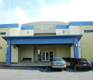
Guam Community College Allied Health Center
This project entails the development of an Allied Health Center at the campus of the Guam Community College. The facility includes classrooms, administrative areas and associated facilities for the allied health program at GCC. The project also includes site improvements such as two (2) entrance and exit points, including walkways, parking lots, and water storage tank. DB&A provided civil and structural engineering design services for this project.
Boundary Survey, AAFB Properties, Guam Land Use Plan, Guam, M.I.
- Boundary survey of parcels totaling over 20,000 acres
- Preparation of parcel maps for disposable and retainable U.S. Air Force properties at multiple sites, both on and off base
- Preparation of legal descriptions for each disposable as well as retainable parcel
- Monumentation of over 340 property corners
The project was undertaken as a quasi joint venture of Duenas & associates, Inc. and Perry Associates, Inc. The work involved the boundary survey of over 20,000 acres of U.S. Air Force properties as part of the Guam Land Use Plan program (GLUP 77 and GLUP 94). The project encompassed on as well as off-base properties.
The project involved extensive use of D&A’s Leica SR399 Real Time GPS Survey System for locating both existing and new property boundaries and corners, and for final property monumentation. Field data was downloaded into a transition program, then into AutoCAD for map production. Over 30 Separate property maps were prepared for AAFB “disposable” and “non-disposable” properties.
The project is relevant to this proposal because it establishes D&A’s intimate familiarity with all AAFB properties, survey controls, monuments and boundaries. It also establishes our capabilities to perform the work using state of the art GPS survey equipment.
Cost of Project:
$487K (total fee)
Cost for which Firm Responsible:
$395K (fee)
FY98 Improve Family Housing, AAFB
Sub-Contracted by HNC Architects for provide both surveying and civil design services, involving the improvement of Family Housing for 64 units at Andersen Air Force Base, Guam.
Work included:
- Topographic survey to support the design of civil site improvements and tie-in to existing infrastructure
- Design of approximately 5200 linear feet of waterline replacement
- Design of approximately 6540 linear feet of gravity sewer lines
- Design of driveways, carports and other site improvements
This project demonstrates the firm’s experience on survey work involving new site development and connection / rehabilitation of existing infrastructure within Andersen Air Force Base.
Hydrographic Survey of Mobil Fuel (Golf) Pier, Guam
Key Features
- Provided Hydrographic survey for determining water depths and bottom conditions
- Utilized real-time Global Positioning System(GPS) survey equipment, electronic fathometer and Hypack navigation software
- Data used to determined if dredging is required for particular tanker ships
Performed hydrographic surveying services for Mobil Fuel Pier (Golf Pier) to determine the underwater contours. The survey was necessary to ensure the area around the pier was capable of harboring scheduled fuel tankers.
DCA used boat mounted GPS and fathometer equipment in conjunction with boat navigation software linked to the GPS equipment. This enabled the boat to stay on course along predetermined survey lines as the fathometer recorded the bottom depth. The result is a fairly quick hydrographic survey which is downloaded in the office to produce an accurate depiction of the ocean floor near the pier. Hard copy and electronic copies of the hydrographic survey were provided to Mobil.
Agingan Wastewater Treatment Plant and Ocean Outfall
Project highlights:
- Topographic and as-built surveys
- Environmental assessment and permit preparation
- Coastal Resource Management Major Siting Permit representation
- Civil engineering design of outfall alignment
Summary:
DCA was the lead member of a multi-disciplinary team that designed a new 1,100-foot long ocean outfall to replace the existing intertidal outfall serving the Agingan Wastewater Treatment Plant. The new outfall will discharge secondary treated wastewater at the 100-foot depth approximately 650 feet west and seaward of the existing outfall, via a 24-inch diameter High Density Polyethylene (HDPE) pipeline outfitted with a 24-inch diameter single port Tide Flex diffuser valve at its terminal end.
DCA’s Environmental Services Division prepared the supporting environmental documents, including the Environmental Impact Assessment, 401 Water Quality Certification Application, Department of the Army Permit Application, and Coastal Resources Management Major Siting Permit Application. The Environmental Services Division represented the Commonwealth Utilities Commission at public hearings in the course of securing these local and federal permits. The permitting process also involved consultation with the State Historic Preservation Officer pursuant to Section 106 of the National Historic Preservation Act, and Informal Section 7 consultation under the Endangered Species Act with the U.S. Fish and Wildlife Service (Region 1) and National Marine Fisheries Service in Honolulu.
Pole Location and Inventory Services, Commonwealth Utilities Corporation, CNMI
This pioneering project involved the physical location, mapping and identification (tagging) of all power poles on the island of Saipan. Also located and mapped were all service drops and meter locations on the island. This work was conducted using several teams operating concurrently to collect field data, survey locations and identify facilities. Tags were prepared using owner specified materials in structured numbering scheme utiliizing coordinate data. Fieldwork was expedited using a combination of conventional and GPS survey methodologies and equipment. Laser rangefinders were also used to expedite collection of data and obviate the need for entry on private property to secure survey data for the service drop and meter locations. Digital data collectors allowed for the immediate download of all data collected on a daily basis, thereby enabling the concurrent reduction and mapping to proceed as the field work was completed
Natural Resources Species Survey & Monitoring Plan, Naval Installations, Guam
This project included completer wildlife assessment and monitoring plan development including location and mapping of monitoring station locations for future monitoring activities. The work for which D&A was directly responsible or jointly responsible included
- Literature review and interviews
- Review of existing geographic information systems (GIS) and grid structure
- Establishment of permanent reference grid for this and future monitoring events
- Characterization of vegetative cover within certain portions of the naval installations
- Development of monitoring plan, protocols, sampling program, monitoring database and reporting systems
- Implementation of monitoring plan and development of baseline report
Masso Reservoir
Project highlights:
- Delineation of wetlands within 29.6-acre property and preparation of official wetland map
- Preparation of Environmental Assessment and permit applications for Department of the Army permit (U.S. Army Corps of Engineers), 401 Water Quality Certification (Guam EPA), Federal Consistency (Guam Coastal Management Program), and Guam Land Use Commission Wetland Permit
- Hydrographic contour survey of Masso Reservoir and preparation of topographic survey map
- Preparation of engineering designs for the rehabilitation of the Masso Reservoir and surrounding areas
- Design and survey of nature trail featuring trees in the Department of Agriculture’s reforestation project on the Reservoir grounds.
Summary:
Apra Harbor Parcel 2 in Piti, Guam, is currently managed by the Guam Dept. of Agriculture as per a three-way agreement with the U.S. Navy and U.S. Fish and Wildlife Service. The Guam Dept. of Agriculture and Guam Dept. of Parks & Recreation are developing the Masso Reservoir area into a public park to include recreational activities, such as sport fishing, camping and nature walks, while still maintaining the natural biological integrity of the site.
Engineering designs were completed for the dredging of the Reservoir from 5 to 7.6 feet deep, and the construction of an embankment, a coffer dam, fishing access retaining wall and overflow channel. Baseline water samples were obtained from five stations within the Masso Reservoir; each sample was analyzed for turbidity, total suspended solids, settleable solids, nitrate-N and phosphate-P. Since the major work was conducted in the Masso Reservoir and surrounding wetlands, which are inhabited by the endangered Mariana common moorhen, various environmental permits needed to besecured prior to any construction workin the area. An official wetland map of the site and an Environmental Assessment were prepared to support the following permit applications: Department of the Army Permit, 401 Water Quality Certification, Guam Coastal Management Program (GCMP) Federal Consistency and Guam Land Use Commission (GLUC) Wetland Permit. These permits were secured and work at the site is nearly complete and will soon be open to encourage public enjoyment and appreciation of our island’s wetland, terrestrial and aquatic resources.
Wetland Delineation and Mapping, COMNAVMARIANAS, Guam
D&A provided wetland surveys and mapping for Naval properties comprising approximately 4500 acres. During the performance of these surveys, a combination of GPS systems was used to locate approximate property boundaries to serve as limits of work. Although not included in the requested scope of work, this innovative approach allowed D&A to complete the project on-time and within budget without using traditional boundary survey methods.
D&A survey crews and our team of biologists delineated 343.3 acres of wetlands comprised of 48 different wetland sites. D&A documented these sites on a total of 24 maps. Extensive regulatory coordination was conducted to insure expedient concurrence and approval of the wetland maps by the appropriate government entities.
Key Features:
- Delineation of all wetlands on specific Navy properties
- Aggressive schedule for completion
- Precise survey of wetland areas
- Use of GPS systems to locate proximity of project limits, avoiding time and costs to conduct boundary surveys
- Quickly obtained verification and concurrence of USACE
- Preparation of 24 official wetland maps.
AT&T TOCI Expansion – Design Build Expansion of Tumon and Tanguisson Telecommunications Stations
Project highlights:
- Addition of an entire building floor to existing subterranean communication facility at Tanguisson and a new single story building at Tumon
- Multi-disciplinary coordination of complex design-build project
- Strenuous industry design and construction standards for telecommunications facilities
- Critical system redundancy maintained in new design as well as during building construction
- Challenging cliff-side terrain with spatial constraints at Tanguisson site
- Allows for future expansion of communications capacity at both facilities
- Topographic/as-built survey, design management, civil design, construction management
- Engaged, negotiated and administered construction contracts for $11 million of telecommunications facilities improvements
Summary:
D&A was retained to provide design andconstruction management services on this complex design-build project. D&A met with the client, examined the existing subterranean facility as well as the desired improvements to determine the functional and operational requirements of the project. The project team then worked to provide conceptual design alternatives, which maximized efficient use of the available space, while minimizing anticipated construction costs in light of the identified constraints.
The final design incorporates replacement/relocation of critical power systems and attendant mechanical/electrical systems; increase in usable space of existing building; addition of new usable space with new floor; replacement of water storage and distribution system; added HVAC capacity; added telecommunications capacity; improved access and equipment transport system; improved infrastructure for future addition of cables; and improved building security.
During Construction, D&A provided construction management services in accordance with AT&T’s stringent quality and safety standards and was able to meet their aggressive completion schedule. Close communications with the client contributed to the success of this project.
Central Tumon Wastewater System Study
DCA performed an assessment of the Central Tumon Wastewater System for Access Ypao which included:
An in-depth review and analysis of the as-built conditions, configuration and capacities of existing wastewater collection and transmission systems in Central Tumon, Guam based on a review of available documentation, past wastewater facilities planning and engineering studies and field verification of transmission system sizes, slopes and inverts.
Updating of projected wastewater loadings within the Tumon service area based on current land use trends and expected ultimate development of commercial and resort properties.
Computerized modeling and analysis of the capacities of the existing systems to meet existing and projected wastewater loadings within the Tumon service area using MHW’s H2O Map Sewer.
Recommendations of phased Tumon wastewater infrastructure system improvements to meet current and future wastewater generation based on existing land use and projected land development proposals.
DCA also provided the engineering design of Phase 1 improvements under a subsequent contract with a developer as a condition of approval for connection to the public wastewater system.